We had
dinner at a quaint restaurant, Manning's Café, in Oakridge, OR. You could have breakfast, lunch or dinner all
day - your choice. It appeared to be
popular with the locals, good food and good prices. We came in shortly before closing, but our
server and kitchen staff were very friendly and didn't rush us at all. In addition to a wonderful omelet dinner,
with homemade bread and great hash brown potatoes, they had the most incredible
homemade pies we had seen on the trip. Reviews on Yelp rated their pies as the
best, so really breaking our diet, we had pie.
They had a great selection of delectable pies and we couldn't decide
between the 1 hour old banana cream strawberry pie or the marionberry pie, so
we got both! At $3.50 for a huge slice,
we ate one and saved one for the next day’s dessert.
The next day
as we neared our campground, the air was filled with smoke. Evidently smoke
from the Lassen NP fire was being blown in our direction. Luckily the campground was clear of smoke,
but the areas surrounding Crater Lake still had remnants of hazy smoke.

Crater Lake National Park http://www.nps.gov/crla/index.htm is located in Oregon. The lake is 1,943 feet deep, the deepest lake in the United States. It is between 4.5 and 6 miles wide, as its not a perfect circle. The edges of the lake are the remains of the cauldera of Mt. Mazama.
The park has many things to offer. We hiked a few trails, one was to a waterfall,


another was to formations called The Pinnacles; fossilized fumaroles formed when gas was forced through the volcanic ash during an eruption.

We also drove the crater rim road, 33 miles in circumference through pumice deserts, forests and steep rock walls. Of course the main event at the park is the beautiful "deep blue" crater lake.


As all advance reservations were booked, we had to get to the park in the morning to see if we could get one of the few remaining seats for the following day. Luckily we were able to get two seats and the next day we set out for Wizard Island.

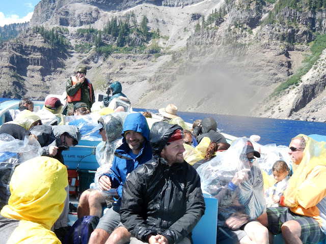
The boat
ride to Wizard Island required that you hike down a mile to the docks at water
level, approximately 700 feet below the rim.
You also had to hike back up at the end of the day, in addition, the
hike to the top of Wizard Island was also a little over a mile and 700 feet elevation
and you had a limited time to get up and make it back to the boat, especially
if you didn’t want to be left behind. I
really thought the hiking would be the most challenging, but it turns out the
boat ride was. The water is
approximately 50 degrees and it was windy that day. As the wind blew across the crater, it
whipped up the waves and consequently the spray and everyone was half soaked by
the time we reached the Island. The park ranger narrating the boat ride said he had never seen it that rough!


View into the cindercone's crater at the top of Wizard Island
We also made some new friends. They especially liked Tony.

I think the
feeling was mutual!
We made the
hike up to the top of the cinder cone and back down in plenty of time to catch the boat. Luckily water on the trip back was not so
rough. Tony and I made a speedy ascent and went
to the Crater Lake Inn to watch the sunset.
Unfortunately, the sun was already below the crater rim and clouds had
moved in, so after a long day, we set off for our campground. What a pleasant surprise when the sun broke
through the clouds over the mountains and gave us a great evening show.
No comments:
Post a Comment